


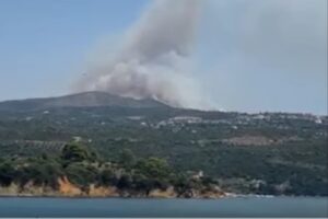
Forest Fire Diseases in Greece – live map
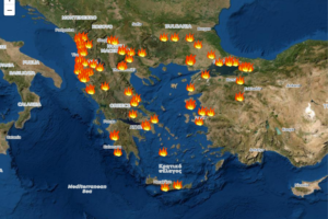
See on the interactive map below the fires raging now (live) in Greece (with data from the last 24 hours). You can navigate to any point you wish by zooming in/zooming out and moving on the map.
The source of the data shown in the map above is from the NASA FIRMS (Fire Information for Resource Management System) service. This service provides near real time (NRT) fire data within 3 hours of their monitoring by satellite, specifically through the Moderate Resolution Imaging Spectroradiometer (MODIS) system on the Aqua and Terra satellites, as well as the Visible Infrared system Imaging Radiometer Suite (VIIRS) aboard S-NPP and NOAA 20 (aka JPSS-1). mykosmos.gr has isolated and depicts the fires of Greece and neighboring countries.
More Infos about Forest Fires in Greece
more about Fire Disasters

last page update: 26. July 2022 (not map content)
published: 26. July 2022
Add a Comment